Category: USCGC Healy Page 10 of 12

Blog 3: Day 14 – Waiting out the ice

Hello world,

It is day 14th Sunday, and is time for me to update you on what has happened on the ship since the last update.


While I was writing my last post, the ship was just passing through the Bering Straight, and we were about to enter the Arctic circle. Since then, we have continuously traveled northeast up to 75 45N 151 15W, which is almsot as north as the middle Greenland! Woah, that’s pretty north. For the next 430 nautical miles (1 nm = 1.15 miles), the seafloor was between 30 and 40 meters! ONLY 40 METERS! That’s 130′, which is way less than half of the Healy’s full length, 420′. While being mindblown by that fact, we made a pit stop to deploy a NOAA mooring. Because we have expert mooring scientists and technicians onboard, notably chief scientist Peter Worcester and tech John Kemp amongst others, a group of NOAA scientists have ask us to deploy an passive acoustic mooring up here. A mooring has an anchor, a long line the links the anchor to devices to the buoy/s that keep the whole apparatus upright. We have been told that the primary objective of this mooring was to monitor bowhead whale vocolization, but since the hydrophones (underwater microphones) will be recording 24/7, it is expected to record ALL sounds produced underwater. The mooring will be recovered by University of Alaska’s R/V Sikuliaq in several months. After that quick deployment, we proceeded northeast to our stations.


Now, our main project, led by Peter Worcester, is to deploy 6 moorings with scoustic sources and 1 passive acoustic mooring with a ton of hydrophones on it. The 6 moorings will be deployed in a pentagon shape, with 1 mooring source being in the center of the pentagon. The hydrophone mooring will be deployed slightly west of the center acoustic source. Using this acoustic source and hydrophone setup, he wishes to study how sound propagates in the Arctic. What makes sense, but may not be thought of by us who do not study that Arctic, is that sound is affected by the physical properties of the medium is travels through. In water, sound has a very fast velocity (approx. 1400 meters per second), and if the water gets colder, the water becomes denser, and the sound speeds decreases. Once we locate the exact locations of all of the sources and the hydrophones, the scientists can use this to measure the sound velocity in the Arctic. Why is this being studied now? The ice coverage and the water temperature is changing, and it is important to know how the current Arctic deepwater affects sound travel.


Okay, so that’s the cool science that is happening on the ship. We deployed the NOAA buoy and one acoustic source. We traveled further north to our station location furtherest north, but because of slightly excessive winds and ice coverage at our station, we decided to relocate to another station. In the meanwhile, the techs identified that we possibly have a faulty GPS antenna, that is affecting our multibeam (seafloor mapping system)**. We have two antennas that help locate our position for the multibeam system, and since one of them is down, the multibeam is having to depend on a single satellite antenna, which is not ideal but still functions enough. For our mapping purposes, it is critical that we know our exact location so that the seafloor data is relevant. We even have a scientist from the government agency National Geospacial-Intelligence Agency to investigate the quality of our seafloor raw data, because they use it for their hydrographic charts. Other than that, the lab has been a quiet place; I have continuously been shadowing Brandon and Keith as they approach connectivity issues with some of the computers and systems, but everything has been smooth for the most part.


**I wrote that the faulty GPS system was part of the multibeam, but I misspoke. The GPS system associated with the multibeam is working perfectly, but actually the GPS not working well was associated with our MRU (motion reference unit). It is still being troubleshooted for.


The image below is myself redoing the connection between the antenna and the GPS cable. I was up way higher than it looks in the photo.


Photo by Sadie Wechsler

Blog 2: Day 7 – I think I see Russia

Hello world,

Justin Miyano reporting from the Bering Sea/Bering Straight. It is day 7 of my MATE internship and day 5 since we have gone underway. The water has been a little rough today but nothing unexpected.

Figure is of our current location.


I realized that I had not introduced myself in my trial blog post so here it is:


Born and raised in Japan, I have always been drawn to the ocean whether it be hanging out at the beach, learning how to surf, or seafood. That led to my undergraduate career pursuing a degree in biology with a focus in marine biology. I graduated from the University of Hawaii at Manoa in 2014, and after a few volutneer positions, internships, and working for UH, I made it here as a Marine Advanced Technology Education (MATE) intern! Ever since I first sailed on a University-National Oceanographic Laboratory System (UNOLS: https://www.unols.org/) vessel and observed the techs onboard, I have been attracted to the career of a marine technician. While the USCGC Healy is not a traditional UNOLS vessel, being on an icebreaker and witnessing the colleboration between various research institutions and the US Coast Guard is pretty spectacular, not to mention I WILL BE IN THE ARCTIC.


So here we are, day 5 underway. As a MATE intern, I have been shadowing the two STARC (Ship-Based Scientific Technical Support in the Arctic) technicians Brandon D’Andrea (Oregon State) and Keith Shadle (Scripps) as they prepare for the science mission ahead of us. Onboard we have scientists and personnel from Scripps Institute of Oceanography, Woods Hole Oceanographic Institution, Naval Postgraduate School, University of Miami, Oregon State, and OASIS INC.


Under the umbrella of resposnsibilities of marine technicians, there are equipment and sensors that collect data such as meteorological data (i.e. air temperature, wind, humidity), vertical depth profile data (echosounder/singlebeam acoustics), position and orientation of the ship (multiple GPS systems and Motion Reference Units (MRUs – sensor for roll, pitch, and yaw)), seafloor mapping (multibeam acoustics), and the Conductivity-Temperature-Depth system (CTD; a package of electronics and large bottles that are sent down to collect such physical properties of the seawater corresponding to depth and can also capture water samples). Some of these I have seen and worked with a little, but each ship has its own unique set up, and it has been fun following the technicians and learning about how to prepare these devices/systems. As a matter of fact, there have been issues where some of the computers were not reading the incoming meteorological and GPS data, and the technicians have been running around the ship to locate the source of the problem. There are still some other systems that I have not listed that are critical to research cruises but I will talk about them another time.


We will probably enter the Arctic Circle tomorrow. I am fully expecting to be greeted by some narwhals at the entrance.


*Because of limited internet, I could only post one image. More to come in the following posts.

Blog 1: Day 0 – Pre-internship post

Hello world,


My name is Justin Miyano, and I will be a MATE intern onboard the USCGC Healy from 8/15 for approximately 5 weeks, cruising up in the northern waters and perhaps even venture on some ice! I flew into Anchorage, AK this morning from Honolulu, HI, and what a difference. I have never been to Alaska so I am looking forward to a little bit of exploring Anchorage, Seward, then Nome at the end of the internship.

Looking forward to sharing all of my expriences throughout my adventure on the Healy!

Aloha,

Return and Reflect

10/08/16
Blog 7- Return and Reflect

I have finally returned home and am writing from far inland. Now that I am hundreds of miles from any ocean I can only reflect upon the many photos, memories, and the box of seafloor rocks I shipped home from Seward. This internship has been truly fantastic and I consider myself very lucky to have been able to participate. I learned alot about the life and work as a marine technician and had a blast doing so. There are no more winch line terminations or soldering to do. No more ROV dives to watch. No more troubleshooting and making things up as you go along. But at this point I think there will be in the future. 

I would like to extend many thanks to Mackenzie, Larry, Croy, Steve, Sarah, and scientists of Chukchi Borderlands 2016. Thanks to the US Coast Guard and crew of the Healy. And thank you Nandita and the MATE program. Good luck to the other MATE interns as well. I’ll enjoy reading your posts!
 

Nick

Moorings and Transit

03/08/16
Blog 6- Moorings and Transit

Today marks the last day of standard science operations. Having finished the last ROV dive yesterday we only had moorings to do today. Moorings consist of instruments attached along a steel cable with a weight on the bottom and floats on top, which keep the entire assembly upright. The Board of Lies was true to its name: listing arrival on station at 0700 and start of mooring operations at 0800, where in actuality nothing happened until well after 1400. 
But even after an interesting morning (playing Monopoly Coast Guard Edition with some of the crew) the recovery and deployments of two of three moorings went off without a hitch. Unfortunately one of the moorings never responded to our pings so it wasnt recovered. This was only a small dissapointment in the scope of the last week of otherwise successful science ops.
Before moorings, scientists and crew had been working in the nonstop cycle of daytime ROV deployment, box coring, CTD casts, and multinet sampling. On one of the last dives I decided to check out the ROV control van (aka shipping container) since I had not seen the inside yet. 
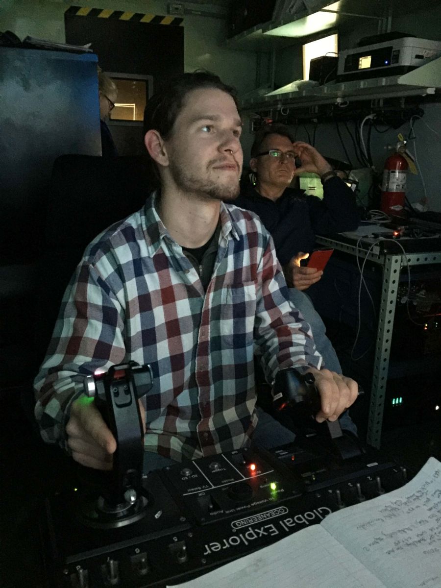
Luckily for me, I stayed long enough to watch the end of the dive and was invited to drive the ROV on the way up from the seafloor! The controls were reminiscent of a video game in that your hands were on a joystick and a lever, and your inputs could be seen with the on-screen attitude display. The constant feeling that your slightest movement would precisely move a very expensive VW Beetle sized submarine located at the end of a 900 m (~3000ft) cable was quite remarkable. 

We have now been sailing south towards the Bering Strait for about a day and have rounded Cape Lisbourne, and the ship is properly pitching and rolling now that we have left the ice. And since today is the 226th birthday of the United States Coast Guard we took advantage of the sunny and 40F weather to have a birthday barbecue on the flight deck. Even though there are no science operations, a lot of undoing the scientists’ set ups and packing samples will happen over the next few days so we are prepared for offload in Seward.

Photo thanks to Stuart Ireland


Creatures of the Pockmarks

26/07/16
Blog 5- Creatures of the Pockmarks
Things have been going swimmingly here on the Healy, even though we have finally run out of fresh vegetables. We are regularly deploying instruments and taking various types of samples. One of the most exciting deployments is the remotely operated vehicle, where humans get to take on the role of aliens shining light into a dark unknown world, sucking up organisms for later probing upon arrival to the mother ship. These blue-faced aliens usually crowd around to watch the live blue video feed on the 70″ monitor whenever the ROV is in the water. Spiders, worms, leeches, snailfish, and jellyfish are only a few kinds of the myriad bottom dwellers that have been seen.

But other sampling methods that bring up the microfauna are just as exciting in their own way. The multi-net in particular sometimes becomes very finicky and so Croy and I have to go try to fix it. This instrument uses a “smart” winch cable, so called because its core is a bundle of conductors, which feeds back to the winch, through a junction box, and eventually to the control box from which the scientist triggers the nets. 
Ideally the multinet is deployed, dropped to the bottom (or some other target depth), and raised through the water column while the scientist sends signals to open and close different nets. This gives a good idea of the copepods and plankton that exist in different sections of the water column. 

Unfortunately, there have been communication problems between the control box and the net itself. After application of various troubleshootings we determined that the problem might lay with one of the conductors within the winch cable. We cut off a section, and then reterminated the multi-net electronically and mechanically. (see photo)

Also, the pockmarks I mentioned in the title are the ~75m depressions in the seafloor, roughly 300m in diameter, which we preferentially sample during benthic ROV dives and with the box corer. They seem to be traces of methane hydrates degassing in response to warmer water temperatures. 

This week’s picture is brought to you by Croy Carlin: Nick soldering winch to multi-net in the Arctic

Station to Station

19/07/16
Blog 4- Station to Station

Those of you following my posts should remember that the last time I wrote was from the middle of a metro-sized melange of multi-year ice. We have broken free and have since been conducting science operations, of course barring the occasional winch problem or encroaching ice chunks.

Today marks the arrival at the sixth science station, and we have just begun working down our standard list of ops. We are currently deploying the CTD, a water sampler that measures conductivity, temperature, depth, salinity, pressure, … in real time. The list goes on depending on what sensors are attached. Afterwards the ROV will get sent over and dive to the seafloor to look for very odd animals, perhaps even sucking a few up with its vacuum arm. Following the ROV dive are the multinet for sampling plankton through the water column, a box core for taking a cubic sample of the seafloor, and a trawl which has unfortunately been the most affected by the presence of ice. Working through the list is a 24 hour operation and scientists, marine techs, and crew change accordingly. It typically takes somewhere around eighteen hours to complete this list before we move on to the next station, rinse and repeat.

So far the responsibilities as a STARC (Ship-based Science Technical Support in the Arctic) tech on the Healy have been somewhat relaxed since there arent any major failures of mission critical instruments. Sure the multibeam system likes to crash occasionally, a meteorological sensor or two likes to spit out impossible data, or the gravimeter needs to be reset, but generally these are easy fixes. The scientific instruments are also performing very well.

One of the more fun things I get to do is to get out on deck and attach a pinger to the winch cable for the box corer deployment. This ~80lb yoga mat sends a 12kHz acoustic chirp as it descends so that we can “watch” it with the ship’s echosounder. This allows us to let the scientists know exactly how far the box core is from the bottom. 

Photo thanks to Stuart Ireland

Backing and Ramming

11/07/16
Backing and Ramming

Since I last wrote we have made considerable progress: We sailed through Unimak Pass in the Aleutians, north through the Bering Sea, past the Diomedes and the Bering Strait, and finally across the Arctic Circle. Though now our progress has come to an icy halt. Four days ago we began crunching through thinner first-year ice, avoiding pressure ridges and following the path of least resistance as far as it would take us. 
This lasted roughly a day before the ice got so thick that we had to begin the process of backing up and then ramming into the thick multi-year ice. This has been going on virtually constantly over the past 48 hours. Our GPS trackline has changed from straight on course to a curved sawblade, as we back and ram constantly within the drifting ice. Fortunately we are drifting towards our waypoints where we can then hopefully begin science operations. I say begin because we have only done two test stations which were meant to smooth the process of deploying and recovering the instruments. 
The samples and measurements from the trial stations were nothing groundbreaking so the science party has little left to do but wait. The marine techs and I are also in somewhat of a holding pattern. We have been able to help some of the scientists get their instruments talking nicely with their computers and making sure the Healy’s veritable cornucopia of geophysical sensors are functioning. So far this has involved making terminations for winch wire, rewiring communication lines, cocking niskin bottles (for water sampling), and of course power cycling the gravity meter. Quite alot of time has also been spent trying to figure out the server that displays the map, position, and various image overlays like the daily satellite ice image. When not doing any of the above we’re usually eating, watching ice break from the bow (never gets old), or looking out for wildlife. Speaking of which we have seen THREE polar bears in the past four days. A pretty spectacular start I think. 
And again I will say I will have some updates by next week since we will have made our first (hopefully second) station by then. It has been said that “No plan survives contact with the ice”, and that is certainly ringing, or rather, rumbling true.


Photo of Nick and MapSurfer from Croy Carlin
 

Holiday at Sea- Week 1

04/07/16
Holiday at Sea

Happy 4th of July from the USCGC Healy! Today marks day 3 on our expedition to the Arctic and things have been going smoothly. We have been sailing southwest along the Aleutian Trench since the day before yesterday and I anticipate we will make a right turn into the Bering Sea sometime in the next day or so. Since today is the 4th there are a few activities scheduled: the crew will kick off a cornhole tournament (possibly ping pong) and there will be some sort of “pyrotechnic training”. There is also a USA themed movie marathon on the ship’s tv channel.
Since getting on board, I have slowly been able to find my way around the ship both physically and on the various networks we have here. Step one was finding the route(s) between the computer lab, stateroom, and mess deck. From there I could begin mounting troubleshooting strategies for the various instruments we have here. 
Much of the work we have done so far is to make sure that these instruments are sending accurate data to the right place. If you want a visualization any of these, they are usually a black cylinder with various tubes and plugs leading in and out. Yesterday I checked that the fluorometers (which measure how much chlorophyll is in the water) were calibrated and sending that data to the right port on the network. I later checked to make sure the configuration file for the computer that runs the instruments on the CTD (a water sampler that also measures conductivity, temperature, and depth) was set up so that the serial numbers matched. And the day before we left Seward my mentor, Croy, had me change a gyro on the gravimeter in the bottom of the ship. I worked very carefully since it was one of the more sensitive (and expensive!) instruments on board. It made a full recovery with its new gyro. You don’t often get to work with the guts of a gravity meter.
I’m learning alot obout the serial interfaces between instruments and computers as well as the myriad software that parse the data. Day to day duties involve looking at all the various fires and then trying to put them out, which keeps things constantly changing. 
This also reminds me: We had our first actual fire alarm yesterday! Nothing major, but since it was a few hours after the first drill it caught a few by suprise. 

Perhaps next week I’ll be able to say that everything is running perfectly. However I’m dubious, plus we will be at our first station by then so I’ll have some updates.

Until then,
Nick


Photo cred: Croy Carlin of the OSU Martech group

Blog 3, Final

Blog update 3

After a ten day journey, I have finally returned home. My journey has been an incredible experience. The USCG crew flew their way across the Pacific Ocean and arrived at Seward Alaska 1 day ahead of schedule. The ship couldn’t dock at Seward the day we arrived because it was busy unloading containers from cargo ships.  Instead, the coast guard arranged flight ops with the air operation division in Kodiak, Alaska. For most of the day, a helicopter landed and took off from the ship helipad to practice in case there was an emergency. I was able to come close to it and take some pictures.

In general I really enjoyed this trip. I love that I learned so much about while under way on the ship. Andrew and Kyle were amazing people to work with, very helpful, intelligent and all around good people. Casting the CTD was one of the most fulfilling part of the trip. Me and Kyle worked on having it ready for a test cast. We installed an altimeter, flourometer and transisometer to the CTD. All nerves ended when the CTD came out of the water and all its components came up. 

The adventures I had on this internship will stick with me for a long time. From getting sea sick the first day of the trip to walking out the door and seeing land for the first time after they voyage. Adventures and experiences like this are the reason why I really want to be a Marine Technician. Apart from cool adventures, helping out troubleshoot a machine that goes up to 4000 meters under the sea is also fulfilling. I hope to one day, find a job where I can assist marine scientist with their electronics while under way in missions.

I would like to thank the crew of USCG, Andrew and the marine tech, Nandita at MATE and everyone else who helped me receive this internship.  

Page 10 of 12

Powered by WordPress & Theme by Anders Norén