Author: Justin Miyano

Blog 6: Day 28 – The End in Sight

Hello World,


Well where did the time go. It has been almost a month since I began my adventure in Alaska and the Arctic through the MATE program. Tasks have been checked off lists, and we are closing in on the completion of this research mission. Today, we had initially planned on deploying a mooring at our Southeast station, which we had to recover once, due to the sound source malfunctioning. Because we also already deployed transponders around the mooring to triangulate, when we re-deploy this mooring, it has to be within the triangle of the 3 transponders, making this re-deployment a little tricky. The weather has been on the rougher side, so the mooring deployment was postponed until tomorrow, and instead, we are testing a different sound source, in preparation for our final mooring deployment station.

In case I was confusing with my wording, we have 2 more moorings left to deploy. And upon completion, we will head down to Nome, Alaska.


It has been a very calm week for the techs. Every system has been running well with no issues, thank goodness, but it has also been a little slow. When there are problems to solve and devices to prepare for deployment, there is more action and things to learn, and I have been missing that a little bit. So, my main mentor Brandon and I decided today that our final week, we will review all the equipment and systems that the marine technicians maintain on the ship, and also work on preparing to store away the CTD rosette. I am pretty excited about that.


Here is to one last week of learning and finishing up this Arctic adventure!


Aloha,


Blog 5: Day 26 – Pictures!

Myself, troubleshooting met data networks.

National Geospatial-Intelligence Agency analyst, Jason Otero (left) and Oregon State Univ. marine technician Brandon D’Andrea (right)

Jason and two sea gliders that were deployed this cruise.

The ships crew craning one of the acoustic sources from up above to the back deck.

Scientists and technicians attaching floats to the mooring line as they are deployed.

The USCGC Healy bridge and some officers and crew on watch.

Healy crossfit coach, BM2 Ben Ahlin, during a workout.

The lowest the sun went one day, somewhere in the Arctic.

Blog 4: Day 22 – White September

Hello World,


Justin Miyano reporting from the Arctic again. It has been almsot 3 weeks at sea, and I seem to be the only remaining person excited about it. This morning, we woke up to some snow on the outside decks. The temperature has been fluctuating between 28 and 32 degrees, and it is quite cold, but I suppose it is way better than cold rain. Ugh, just the thought of it is giving me chicken skin.


Yesterday, we completed the deployment of our 5th acoustic mooring. Between the last blog I wrote and this blog post, I have communicated with some of the scientists to better understand this project better, and I have learned that, after the acoustic source mooring is deployed, 3 transponders are deployed so that at any given time the acoustic source produces sound, the transponders can triangulate the exact position of the source, which anables the scientists to calculate the distance and speed of the sound traveled between the moorings. Once the 3 transponders are deployed, we use an echosounder to locate the precise positions of the three.


On the tech side of things, everything has been working well and our days have been mellow, until 2 days ago, when we attempted the troubleshoot what could be the problem with our faulty GPS system and antenna (the POS-MV system). We power cycled the system (a fancy tech word for turn off and on) so that we could attempt various combinations of the 2 antennas, cables, and extensions to find the broken component, but then the whole system stopped functioning. For hours, we tried powercycling and looking at all the connections, reading the computer outputs to see what could have gone wrong but there were no obvious signs. After a long battle with the POS-MV and sending out an email to the manufacturer’s representative who had helped us in the beginning of the cruise, we called it a night. Then, we woke up to a see the POS-MV working again. The computer said that it had started logging information a couple hours prior to us noticing this morning. What a magical white September morning.


On another note, we recently learned that we have a protp-type buoy onboard from a project called UpTempO (Upper Layer Temperature of the Polar Oceans: http://psc.apl.washington.edu/UpTempO/). They study the seasurface temperatures in the polar oceans to help monitor global warming, using these simple buoy systems. The buoys have temperature and pressure sensors from 2.5 to 60 meters deep! The deployment of this buoy is STARC’s (Oregon State University and Scripps Institute of Oceanography) responsibility, so the two techs, Brandon and Keith are pretty excited that we will be working on the deck for a change!


Other than that, we have corn hole and ping pong tournaments to celebrate Labor Day! Woo for some fun. Happy Labor Day weekend everyone.


P.S. It took me 3 attempts to write this blog because the site kept freezing up when I would try to upload a photo so I am not going to upload a photo this time, sorry.

Blog 3: Day 14 – Waiting out the ice

Hello world,

It is day 14th Sunday, and is time for me to update you on what has happened on the ship since the last update.


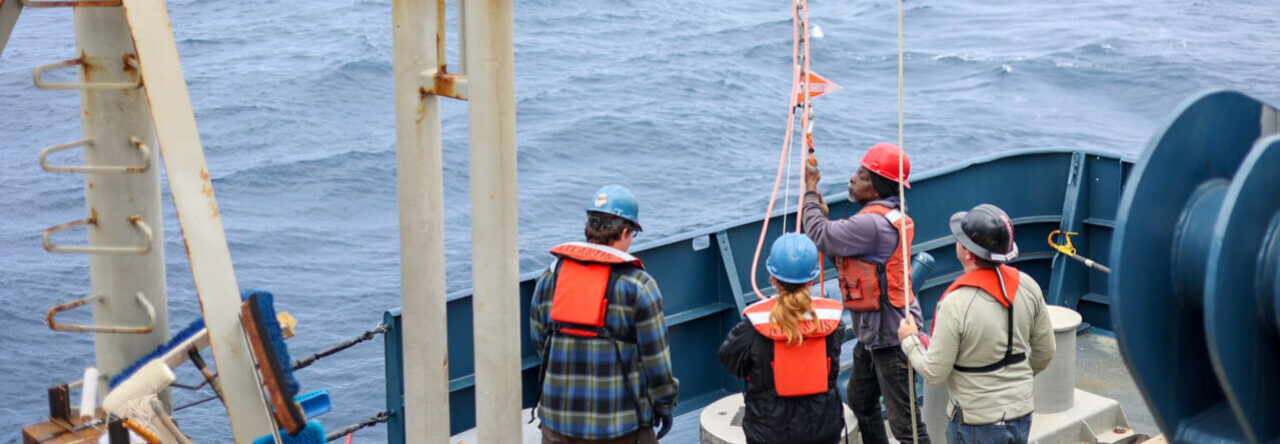
While I was writing my last post, the ship was just passing through the Bering Straight, and we were about to enter the Arctic circle. Since then, we have continuously traveled northeast up to 75 45N 151 15W, which is almsot as north as the middle Greenland! Woah, that’s pretty north. For the next 430 nautical miles (1 nm = 1.15 miles), the seafloor was between 30 and 40 meters! ONLY 40 METERS! That’s 130′, which is way less than half of the Healy’s full length, 420′. While being mindblown by that fact, we made a pit stop to deploy a NOAA mooring. Because we have expert mooring scientists and technicians onboard, notably chief scientist Peter Worcester and tech John Kemp amongst others, a group of NOAA scientists have ask us to deploy an passive acoustic mooring up here. A mooring has an anchor, a long line the links the anchor to devices to the buoy/s that keep the whole apparatus upright. We have been told that the primary objective of this mooring was to monitor bowhead whale vocolization, but since the hydrophones (underwater microphones) will be recording 24/7, it is expected to record ALL sounds produced underwater. The mooring will be recovered by University of Alaska’s R/V Sikuliaq in several months. After that quick deployment, we proceeded northeast to our stations.


Now, our main project, led by Peter Worcester, is to deploy 6 moorings with scoustic sources and 1 passive acoustic mooring with a ton of hydrophones on it. The 6 moorings will be deployed in a pentagon shape, with 1 mooring source being in the center of the pentagon. The hydrophone mooring will be deployed slightly west of the center acoustic source. Using this acoustic source and hydrophone setup, he wishes to study how sound propagates in the Arctic. What makes sense, but may not be thought of by us who do not study that Arctic, is that sound is affected by the physical properties of the medium is travels through. In water, sound has a very fast velocity (approx. 1400 meters per second), and if the water gets colder, the water becomes denser, and the sound speeds decreases. Once we locate the exact locations of all of the sources and the hydrophones, the scientists can use this to measure the sound velocity in the Arctic. Why is this being studied now? The ice coverage and the water temperature is changing, and it is important to know how the current Arctic deepwater affects sound travel.


Okay, so that’s the cool science that is happening on the ship. We deployed the NOAA buoy and one acoustic source. We traveled further north to our station location furtherest north, but because of slightly excessive winds and ice coverage at our station, we decided to relocate to another station. In the meanwhile, the techs identified that we possibly have a faulty GPS antenna, that is affecting our multibeam (seafloor mapping system)**. We have two antennas that help locate our position for the multibeam system, and since one of them is down, the multibeam is having to depend on a single satellite antenna, which is not ideal but still functions enough. For our mapping purposes, it is critical that we know our exact location so that the seafloor data is relevant. We even have a scientist from the government agency National Geospacial-Intelligence Agency to investigate the quality of our seafloor raw data, because they use it for their hydrographic charts. Other than that, the lab has been a quiet place; I have continuously been shadowing Brandon and Keith as they approach connectivity issues with some of the computers and systems, but everything has been smooth for the most part.


**I wrote that the faulty GPS system was part of the multibeam, but I misspoke. The GPS system associated with the multibeam is working perfectly, but actually the GPS not working well was associated with our MRU (motion reference unit). It is still being troubleshooted for.


The image below is myself redoing the connection between the antenna and the GPS cable. I was up way higher than it looks in the photo.


Photo by Sadie Wechsler

Blog 2: Day 7 – I think I see Russia

Hello world,

Justin Miyano reporting from the Bering Sea/Bering Straight. It is day 7 of my MATE internship and day 5 since we have gone underway. The water has been a little rough today but nothing unexpected.

Figure is of our current location.


I realized that I had not introduced myself in my trial blog post so here it is:


Born and raised in Japan, I have always been drawn to the ocean whether it be hanging out at the beach, learning how to surf, or seafood. That led to my undergraduate career pursuing a degree in biology with a focus in marine biology. I graduated from the University of Hawaii at Manoa in 2014, and after a few volutneer positions, internships, and working for UH, I made it here as a Marine Advanced Technology Education (MATE) intern! Ever since I first sailed on a University-National Oceanographic Laboratory System (UNOLS: https://www.unols.org/) vessel and observed the techs onboard, I have been attracted to the career of a marine technician. While the USCGC Healy is not a traditional UNOLS vessel, being on an icebreaker and witnessing the colleboration between various research institutions and the US Coast Guard is pretty spectacular, not to mention I WILL BE IN THE ARCTIC.


So here we are, day 5 underway. As a MATE intern, I have been shadowing the two STARC (Ship-Based Scientific Technical Support in the Arctic) technicians Brandon D’Andrea (Oregon State) and Keith Shadle (Scripps) as they prepare for the science mission ahead of us. Onboard we have scientists and personnel from Scripps Institute of Oceanography, Woods Hole Oceanographic Institution, Naval Postgraduate School, University of Miami, Oregon State, and OASIS INC.


Under the umbrella of resposnsibilities of marine technicians, there are equipment and sensors that collect data such as meteorological data (i.e. air temperature, wind, humidity), vertical depth profile data (echosounder/singlebeam acoustics), position and orientation of the ship (multiple GPS systems and Motion Reference Units (MRUs – sensor for roll, pitch, and yaw)), seafloor mapping (multibeam acoustics), and the Conductivity-Temperature-Depth system (CTD; a package of electronics and large bottles that are sent down to collect such physical properties of the seawater corresponding to depth and can also capture water samples). Some of these I have seen and worked with a little, but each ship has its own unique set up, and it has been fun following the technicians and learning about how to prepare these devices/systems. As a matter of fact, there have been issues where some of the computers were not reading the incoming meteorological and GPS data, and the technicians have been running around the ship to locate the source of the problem. There are still some other systems that I have not listed that are critical to research cruises but I will talk about them another time.


We will probably enter the Arctic Circle tomorrow. I am fully expecting to be greeted by some narwhals at the entrance.


*Because of limited internet, I could only post one image. More to come in the following posts.

Blog 1: Day 0 – Pre-internship post

Hello world,


My name is Justin Miyano, and I will be a MATE intern onboard the USCGC Healy from 8/15 for approximately 5 weeks, cruising up in the northern waters and perhaps even venture on some ice! I flew into Anchorage, AK this morning from Honolulu, HI, and what a difference. I have never been to Alaska so I am looking forward to a little bit of exploring Anchorage, Seward, then Nome at the end of the internship.

Looking forward to sharing all of my expriences throughout my adventure on the Healy!

Aloha,

Powered by WordPress & Theme by Anders Norén