Category: Columbia University, Lamont-Doherty Earth Observatory Page 7 of 10

WEEKS 2-3 ON THE R/V LANGSETH

Week 2

May 17: Alan and I continued to check over the digibird collars for salty erosion and bad latches. Later that evening, I covered for Riley in the main lab to monitor the streamer cable, digibirds and airguns. I kept a close eye on our SOG (speed over ground) and STW (speed through water) to make sure the bridge didn’t go over our speed target which is usually set at approximately five knots. Any speed higher than six knots would lead to high tension on the streamer being towed. This would lead to unnecessary stress and equipment failure. I was able to monitor 10 screens for 10 hours!

May 18: Cody and I went through a weekly gravity check that I was now expected to do every monday for the following weeks. That night Josh (Chief gunner) invited me down to the gun shop where we dismantled an airgun so we could replace O rings. While doing so, Josh walked me through the process of how an airgun works. It was very helpful to have a visual description of the process and it allowed me to have a better understanding of how the air guns create sound waves in the water. I was also able to talk to Bill (geologist technician) and have him explain the sonar pod below the boat. The sonar pod is unique in the fact that it has an ADCP, a transducer, a receiver and a sub-bottom profiler all in one unit that is mounted in the haul! Cool stuff!

May 19: I was finally able to get some laundry washed throughout the day. I also assembled and calibrated 10 digibirds on standby while the crew started retrieving everything out of the water because we had lost signal from our tailbuoy. After I completed my task with the birds I ran around the boat looking for parts and tools that the technicians needed to be able to troubleshoot and fix various instruments. Lastly, I reevaluated 24 birds and put them in order so they were ready for deployment.

May 20 : Alan and I completed our inventory checklist of about 500 digibird collars. Riley needed me to cover him in the lab today so he could continue on another one of his projects he was working on around the boat. During my time in the lab, I had to turn off gun array one so it would be safe for the gunners to retrieve the array out of the water for maintenance. 

Another one of my responsibilities is to convert all navigation and observer logs into PDF format and save them in the correct folders on the server. I also updated the digi bird log on excel. We had been surveying in the gulf stream which led to our streamer feathering off line. With the vessel only allowed to go five to six knots we ended up having to crab our way through the Gulf Stream to stay on line. The navigation screens showed the streamer cable being towed about 90 degrees off our line! 

Week 3

May 21: Together Cody and I went through the rest of the digibirds on deck to test for motors, compass, depth, heading and wing movement on each one so future technicians could keep up with the inventory. I organized the streamer deck from last night’s deployment and touched up the loose piled lines with some line management. Later that evening, we had to bring the guns onboard again due to some electrical leakage. We eventually found where the source of the leakage was through troubleshooting different cable connections with a multimeter for conductivity. After replacing an electrical cable and a GPS unit for the airguns, we had a successful deployment and got off shift. 

May 22: Started my day by completing my work plan assignment with Cody for one of my internship requirements. Cody had then asked me to spray paint all the new radios used for the science team and make sure the current ones were still in good condition. I completed my first weekly gravity check alone with a multimeter and a deck unit in the main lab. Lastly, I ended my night with relabeling most of the monitors, keyboards and mouses in the lab which helped me get a better understanding of the hardware management setup used in the lab. 

May 24: This was a steady day of monitoring data and active equipment throughout our survey. Cody also taught me how to end one line and pre-plot another in the navigation software. We had four meter swells for the majority of the day which eventually became normal to everyone as we kept rolling starboard to port all day. 

May 25: Another steady day of monitoring screens in the lab until 10 pm. At this time, seas had picked up and the digibirds started to struggle to stay at  six meter’s depth. At one point, part of the streamer cable surfaced. Cody and I had to keep switching fin angles and changing depths throughout all the digibirds to fight the sea surface turbulence. Eventually after 90 minutes we were able to stabilize the streamer at eight meters before we got off shift. 

May 26: First thing after waking up, I had to throw on my PPE and go out onto the airgun deck to assist with recovering all airguns and buoys. After that was completed, the technicians and I went upstairs onto the streamer deck to recover all six kilometers of streamer cable that was deployed. My job was to assist with removing the digibirds and replace the collars for each of them (two collars per bird). I also had to assemble and recalibrate 10 more spare birds on standby just in case we had to replace any as we were deploying. We ended up using all 10 birds on standby as replacements for the bad ones that were previously deployed. The bad digibirds that had been taken off were definitely the leading cause for the streamer surfacing to the top yesterday. Recovery and deployment on deck started for me at 12 pm and ended at 10:30 pm. After a long day on deck, I finished a nav log for survey line 40 and created another for line 41. 

May 27: The common phrase I hear on the boat is, “boring data is good data”. After replacing, fixing and a thorough check of all the equipment yesterday everything seemed to be working accordingly. Today was good for data collection while also relaxing due to no errors appearing on our monitors. Our shift led to good conversation and even better laughs while observing data in the main lab. 

Intern Introduction

My name is Claire Mayorga. 

I’m really excited to join the R/V Langseth at-sea. It is such a unique opportunity to join scientists that are mapping the most inaccessible part of our oceans and retrieving deep-sea sediment cores. 

I first became interested in marine geochemistry in university, where I completed my honors thesis collecting sediment cores in salt marshes to study carbon storage. Then, I went on an oceanography research cruise, and fell in love with remote field work.

I’ve spent the last couple years as a field biologist working on different projects, the most recent being a research assistant in the Kalahari Desert. I spent 4 months following groups of meerkats around collecting behavioral data.


WEEKS 1-2 on the R/V Langseth

Hello everyone! Between mobilization and simply learning how the crew and equipment work I didn’t have a chance to post my week 1 blog last week but here I go with week 1 and 2 for this post!


SEISMIC SURVEY MISSION

Why:

The scientists onboard believe there are methane pockets that are trapped in ice that are known as methane hydrates, which is a potential reason for subsea landslides in the deep sea. To help prove this hypothesis we have to go through the survey data and mark the locations where methane hydrates have been located so we can return to these coordinates and drop gravity cores down into the sediment. The gravity core will then collect layers of sediment in a tube and bring it back onboard the vessel where scientists can cut different sections off and freeze them to be studied in a lab back onshore. 

How:

Off the stern of the vessel the technicians and gunners work together to deploy 6km of SSAS streamer cable that record sound waves that are bounced off the bottom of the seafloor. Some sound waves are able to penetrate up to 10km under the seafloor surface. Similar to sub bottom profiler data and we are able to see that data as well. After all the streamer cable is deployed the gunners and technicians will deploy the air guns which are all attached to long sausage buoys that are towed between the cables and vessel. The air guns use compressed air to create a loud blast of noise similar to a gun firing which creates the sound waves that collect data. 


Week 1


May 6th

I arrived at the Virgina, Norfolk airport and caught a 20 min uber to the NOAA pier where the Langseth was tied up at. The uber driver dropped me off at the gate and the NOAA security guard checked my ID and let me in. As I walked to the ship I passed the NOAA office and one of their vessels. They had a big catamaran dock ahead of us which was being prepared for one of their missions. Cool stuff! As soon as I got on, Cody (cheif technican) introduced himself to me and showed me where my room was. I had to find my way down 3 decks to the main lab (the cook had to help me out because I had walked through the galley 3 times and he figured I was lost). I also had a chance to meet the other technicians and gunners onboard. Todd (a technician) helped me get all my PPE which I posted in my introduction blog post.


May 7th

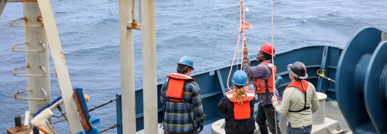
I woke up at 6 am and helped lift floor tiles so I could reconfigure some wires for the main lab which has over 40 monitors! Afterwards, Cody and I attached a RVIM (Rubber Vibration Isolation Model) to the end of one of the streamer cables so the tail buoy would not create tension on the cable while in the water. 


May 8th

Me and Cody went up on the bridge tower so we could set up the PSO’s stations on port and starboard sides where they can keep a lookout through their high grade binoculars for whales, dolphins, turtles, etc. 


May 9th 

This day was my first day on my 12 hour shift schedule (12pm – 12am). We also set sail between 13:00-14:00. Norfolk was interesting to see as we departed from the dock. I saw a fleet of US naval ships docked up and plenty of commercial ports and vessels coming in and out the bay. 


May 10th

I woke up and put my PPE on to help out with deployment of 6km streamer cables on the deck. While deploying I assisted with changing out modules (for more efficient data transfer) and attaching digibirds (model 5000) so we could tow the cables at an appropriate altitude.


May 12 

I helped out one of the gunners drill rust off the hydraulic systems and re-grease it with some heavy duty industrial grease. After I was observing data in the main lab when all of a sudden one of the air guns started to auto fire. We retrieved that gun string and realize the air gun was auto firing due to a corrupt seal. After replacing the air gun and some air hoses we deployed them back into the water and started collecting accurate data again. 


May 13th 

Cody assigned me 3 daily tasks to do at the start and end of my shift.

1. Checking the server for recent incoming raw data

2. Emptying the dehumidifiers in the mainframe room

3. Check the wet lab for running water so we can have updated salinity measurements.

I proceeded to help the gunners replace air lines to some more air guns before redeploying. Cody then showed me how to fill out daily scientific reports for the National Science Foundation (they are responsible for funding this whole mission). The rest of the evening I was recalibrating all the digibirds that were marked red for not usable. I tested the digibirds for accurate heading, depth, pressure, and wing movement. I then removed the bad bird modules and replaced them with working ones.

Week 2


May 14th

Continued recalibrating digibirds and observing data in the main lab.


May 15th

Me and another technician named Alan who I learned is an alumni of the CFCC Marine Technology Program went through the bird collars to fix the latches on the bad collars. We also had to soak some of them in freshwater due to salt erosion locking some of them up. 


May 16th

I spent most of the day studying the different softwares used in the main lab to track different aspects of our survey.

Orca software: is used for navigation of boat, streamer cable, digibirds, survey lines, and general positioning. 

Digicourse: Displays location of digibirds in the water column so we can keep the streamer cable at the correct depth.

Gunlink: shows electrical signals being transferred to airguns simultaneously. It also displays sound output from the hydrophones and airgun health by color.

Seal: shows sound being received as a whole streamer cable using sound bars.

Seal QC: Graphs sound return by Time (s) and length of streamer cable. 

Introduction

Hello everyone,

I am a student at Cape Fear Community College in the Marine Technology Program. This is my first internship and I’m excited for this opportunity. I will be a marine technician intern onboard the R/V Marcus G. Langseth for a month. We will be conducting seismic sonar, ctd’s, gravity coring, and retrieving obs’s. We set sail out of Norfolk, VA.   

The last few days on R/V Langseth

We’re approaching the final day of our trip. I’ve spent countless hours in the Main Lab proctoring communications with the Bridge and our Science team, logging events, and keeping our monitoring systems somewhat in check. We’ve deployed and recovered OBEM’s almost 25 times over the past two weeks, along with having taken our antenna’s in and out several times due to some hazardous water encounters. We actually lost all activity from our porpoise array on their final tow due to fishing gear and long lines in the water. 3 out of the 4 had their electrodes destroyed. You can see where each one was lost when you go back through their incomplete data sets.

Today specifically, we will haul in our remaining Scripps OBEM’s from south of Martha’s Vineyard. As each is brought aboard, it gets somewhat disassembled, removing electrodes and data loggers and then the data is collected from the compact flash cards that the data loggers recorded to. We have left 5 OBEM’s at the bottom of the ocean that will remain for the next year. They were created by WHOI, they sit off the edge of the continental slope in deep water. They will monitor electromagnetic activity they encounter for use upon their collection in the following year.

I’ve learned about launching XBT’s and how the WinMK21 software works. I have played with the different phases, gain, and shadow reduction to get accurate depths on the Knudsen 3.5 Hz Sub-bottom Profiler. I also got some time into the Spectra Robtrack Interface, getting time estimates and seeing our plotted course. Furthermore, I’ve met a great group of people who will continue to contribute knowledge and ability in the future of the marine science industry.

Tomorrow, we will wait for our Pilot boat to bring us to our dock in the morning, probably right before breakfast time. We will begin our demobilization of the ship, collecting our equipment and things all together, and transport them off boat via cranes. 

All I can say is.. what a great experience I’ve had the pleasure of partaking in. I can’t wait to pursue my future opportunities!

~Kate

Looking for freshwater

 It has been such an incredible opportunity to work with scientists from Woods Hole and Scripps Institute in sending down instruments which have never been used for our purpose in mapping freshwater deposits under the seafloor. Working in 12 hour shifts from midnight to noon I have helped to assemble the Ocean Bottom Electromagnetic instruments and outfit them with batteries, hydrophones, and fluxgate magnetometers along with other instruments that will be recording the changes in frequency of electromagnetic waves as they travel through the ocean floor. We deployed those at specific intervals on the ocean bottom off the coast of NJ and then towed a dipole behind the boat that sent current through the water and generated a complex wave form which was then recorded by the OBEMs and also recievers also towed behind the boat. I have also participated in logging every deployment and recovery including Latitude and Longitude, boat and wind speed, course, depth, and have taken readings from echosounders, GPS recievers, Direct Positioning systems, and other complex multibeam sonar. The geophysics is a little over my head, but I get mini lectures from the enthusiastic scientists on board while we sit and tow our array for days, monitoring all systems on computer screens. I’ve also had tours of the bridge and engine room by the excellent crew. I’m loving it so far. We have now picked up the OBEMs after towing for a few days and are now en route to the continental shelf below Martha’s Vineyard, where we will deploy another kind of Ocean Bottom System which will sit below for 8 weeks and again deploy the OBEMs and tow our array before picking them up and heading back to Woods Hole on the 14th.

Week One: The Langseth is hard at work

This post is certainly later than intended, but we’ve been in open-ocean since Thursday morning. Our first two days on shore were spend drilling new holes in the mounting plates for our winch. We used two methods, one of which was a magnetic drill, the other was using a drill press. We were tossed around quite a bit Friday night due to an on shore storm sending some wind our way. At first you don’t think you’ll do so well with the waves and boat motion but your body adapts and you get there. 


The goal of our trip is to use electromagnetic waves to detect freshwater reserves that may be under the oceans crust. We will cover two main plots, one of which has been drilled and fresh water already found. The other is thought likely to have fresh water present. The main steps for detection are to launch Ocean Bottom ElectroMagnetometer (OBEM) stations that will receive data from a long and short towed antenna (called a source) rigged to the aft of the vessel. We will also tow an array of 4 receivers off the aft as well. This way we can identify the most efficient way to detect fresh water reserves under the ocean crust. We are currently off the coast of New Jersey where we have already deployed the OBEM’s and are towing antenna’s above them


The main steps: 

1.) Deploy OBEM’s

2.) Deploy towed array

3.)Deploy the long antenna

4.)Deploy the short antenna

5.)Drive back over the OBEM’s with the vessel at a slow rate to send out signals that can be captured by data loggers.

6.) Retract the antennas, and the array

7.) Retrieve the OBEM’s from the ocean bottom.


After all this is done, we will then travel back north to south of Martha’s Vineyard and repeat.


The crew (Science and Technical) works in rotating shifts, 12 hours each, to make sure data is being sent and any significant occurrences are logged in a daily agenda. They have been a pleasure and quite kind and certainly make such a new experience easier for a new comer such as myself. There’s certainly more to come, and pictures as well when we get closer to shore with a good data connection.


Signing out,

Kate


Week 4- The journey back

Well, it is all coming to an end now. We have started the thirty-hour hike back to the port. We have successfully mapped everything the chief scientist wanted and that has been a lot of ground. So far so good on the travel back as the waves are finally somewhat calm versus how they were yesterday.

Everything that we mapped has been processed and stored away but it does not just end there. This data will be used as evidence to help persuade a point. That point being that we should be allowed to extend our shelf out to the 350 nautical mile mark. Although it may sound unlikely, it is possible through intense and strategic negotiation. The data we collected will also be used for geologists who will have a field day with it due to the significant patterns on the ocean floor.

Of course we are still going to be mapping all the way till were back, or to about 500 meters deep (1,640ft).  It makes sense to just leave the multibeam running because you may be collecting data that hasn’t been collected before. You would much rather collect the data and have to throw it away because it has already been recorded than not collect it at all and miss out. We started mapping from the very second we left the dock and we will continue to do so until we reach the port.

This journey has been a long one but I can say that it has definitely been worth it. I’ve never had the chance to experience anything like this before and I am very thankful as well as grateful for the MATE program to provide me with this amazing opportunity!

Getting ready for the Langseth!

Hello Internet, Kate here! I’m about to embark on my first internship at sea in the coming week, joining the crew of the R/V Langseth. I’ll depart on September 1st from Woods Hole, a town near and dear to me. I’m so stoked! Growing up I would look over to the WHOI dock from one of the many Steamship Authority ferries as I headed to Martha’s Vineyard each year, thinking I want to be on one of those vessels one day. That day is here, well, almost!

R/V Langseth is part of the Lamont Doherty Earth Observatory, I first encountered the ship this past winter during an MTS meeting where we explored one of the WHOI facilities and the Langseth was parked on the dock, featured in the image I posted.

I’ve been prepping for my internship by reading about various equipment on board, getting things all set for the start of my school semester, and communicating with some of Langseth’s technical staff. Oh! and you can’t forget fighting off the minor bits of anxiety that come with an adventure such as this!

In the meantime, I’m enjoying my last week of summer vacation visiting Martha’s Vineyard. Stay tuned for my coming adventure!

Week 3- Home stretch

It is the third week into the cruise! So far it has been twenty-one days out at sea, we have traveled a combined distance of 4,941 nautical miles, and are sitting in roughly 3 miles deep of water (16,404 ft.). It has been a smooth journey thus far with the exception of a detour, which I will talk about later in this blog.

We have been making a lot of progress towards our goal of redefining the continental shelf. The south side had been finished in a good amount of time. We even saved a couple of days worth of work by cutting the last two lines off because we predicted that there wasn’t going to be any data worth our time in those areas. Then, we did our cross line to move over to the north side. When I say “cross line” you may be thinking of the boat traversing perpendicular to its original lines, which is right. What is the purpose of that? Well, by preforming a cross line we are not only moving perpendicular across our planned route but we are also using that line to continue collecting data that we need to help refine the data we have already collected. In other words, when we do a cross line we are crossing over the lines we have already done. This allows us to confirm those lines because the parallel lines have a slight overlay with each line. The cross line eliminates those overlay lines and clears up the data.

As soon as we finished the first two lines of the north side, a crewmember claimed that they were having chest pains. So, without any hesitation, the captain turned the boat around and we headed to shore. Once we were about a mile off shore, we deployed our rescue boat off the side of the ship and put the crewmember on it. They drove out to meet up with another small boat that was going to bring him to shore and then to a hospital. Our rescue boat came back to the ship and was hoisted back on. This whole transfer took a matter of twenty minutes. I was shocked at how fast it was over.

This journey has been very interesting thus far! I can’t wait till the last week when we complete out mission!

Page 7 of 10

Powered by WordPress & Theme by Anders Norén