Author: Claire Mayorga

Langseth take 2: Week 2


Its day 19 of this cruise on the R/V Langseth, and we have been deploying the seismic gear for the last 18. After the 12-hour process of deploying the 12-kilometer streamer, 4 strings of airguns, and 2 sensors, we were ready to being “shooting” and collecting data. Once all the equipment is deployed, we must maintain a speed of roughly 3-5 knots to maintain good tension and depth on all the equipment being towing.

As the airguns shoot (approximately every 50 meters or 20 seconds) it sends a sound signal that penetrated miles into the seabed before reflecting and being read by the hydrophones along the streamer. The hydrophones are extremely sensitive underwater microphones that convert the sound signal sent by the airguns into seismic profiles. These seismic profiles show the layers of the seafloor by recording how fast sound moves through each layer.

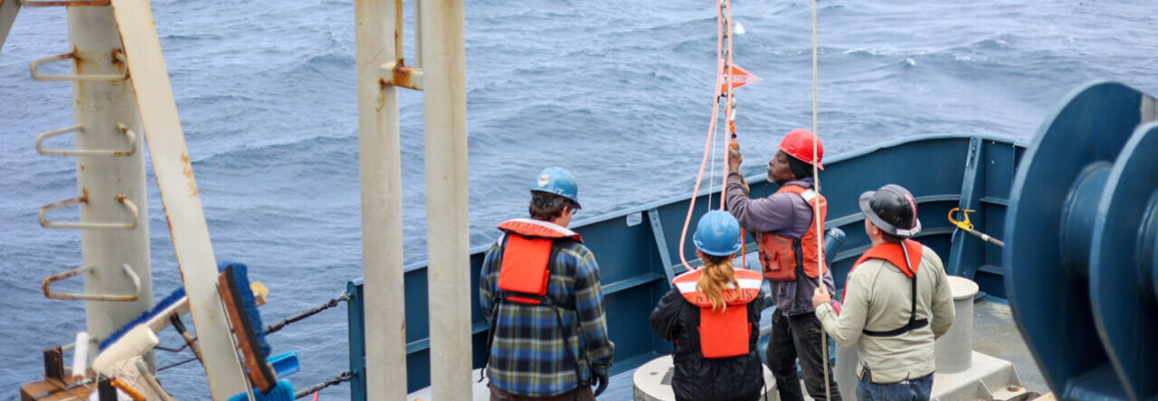
This week we needed to check the streamer and record videos of it firing. I was lucky enough to be chosen to go on the small boat with a few others. We used a GoPro taped to the end of a metal arm that was then lowered into the water next to the streamer. All these photos came from the video.

The yellow buoys are the head floats on each of the 4 gun strings. Each gun string has 9 airguns on it that are towed at a depth of 10 meters. The airguns are the sound source and critical to the data collection.

Approximately every 20 seconds (or 50 meteres) the 36 airguns fire. When they fire, they create a huge sound wave that makes deep-sea floor mapping possible.

Behind the 4 airgun strings is the streamer with the hydrophones on it. The streamer extends for 7.5 miles (or 12 kilometers) behind the ship, and has 47 Digibirds on it. The Digibirds (pictured below on the streamer) use their depth sensor and wings to keep the streamer at a constant depth of 12 meters.

I’m extremely happy that I got to go on the small boat and check out the equipment that we’ve spent so many days prepping, deploying, and watching on screens. Maybe next time I’ll even get to go swimming…

Langseth take 2: Week 1

This is my third and last cruise as a MATE intern aboard the R/V Langseth. This last cruise will be very different that my previous two, which collected sediment cores and ocean bottom seismometers respectively.  This cruise will use the Langseth’s highly specialized seismic equipment to collect multichannel seismic data. It is currently the only UNOLS vessel able to collect this type of data. Essentially, this means we will be towing seismic equipment that uses sound waves to create highly detailed maps of the geological features under the seafloor. 

I have spent the last week working with scientists and contractors from all over the world to prepare the seismic equipment for deployment. I have been gaining an intense crash course in geology, seismology (the study of earthquakes), and basic mechanics.

Here’s the basics[refer to pic below]: The seismic equipment is made up of airguns, streamers, and Digibirds. The 36 airguns create a loud sound that then travels through different layers of the seabed before bouncing back to be heard by the 12 kilometers of streamer. The streamer has thousands of hydrophones (precise underwater microphones) along it that receive the sound signal and create a high-precision map. There are also 47 Digibirds (orange winged “birds”) that use their wings to control the depth of the streamer.

We spent the first 2 days calibrating the Digibirds (pictured in rack below) which help us keep the streamer at a precise depth (12 meters). The Digibirds have a sensor on them that determines depth based on pressure, it then moves it wings up or down to move shallower or deeper based on programmed depth. It was a two-day operation to deploy the entire 12 kilometers (7.5mi) of streamer with hydrophones, 47 Digibirds, and 36 airguns across 4 strings. Now that everything is deployed, we will monitor the equipment for changes as we tow the seimic equipment across the survey lines.

This is a Digibird in the Bird Lab, where we calibrate its depth and test it before deployment. We prepped 55 Digibirds before deploying the 12 kilometers of streamer. 

Here is the back of the boat towing the seismic equipment. The four yellow lines go to the four airgun strings (each has 9 airguns on it; the 4 airgun strings are the sound source) and the white line is the 12km streamer (where hydrophones recieve the sound after it bouonces off the seafloor).

Week 4: C’est la vie

Our cruise retrieving Ocean Bottom Seimometers (OBS) is ahead of schedule. We’ve spent the last four days recovering OBSs around-the-clock.  As the boat floats by the sensor, the scientists attach a line to it, so that it can be raised onto the deck using the winch. During my shift, I operate the winch for the science crew. My skills have definitely improved over the last few days!

On Monday, we had successfully collected 36 out of the 40 OBSs deployed; we were unable to communicate with 4 of the instruments, making them impossible to release from the bottom or recover. With 90% of the sensors on board we began our transit back to Florida late Monday night, two days ahead of schedule.  

We will arrive back to Cape Canaveral (Florida) around 10:00AM July 1st, just an hour before the next SpaceX launch, which will be at 11:11AM! I can’t thank everyone enough for this great cruise. Shout out to Todd and the science crew for the memories.. I’ll be back soon enough..


Week 3: OBS’s everywhere

We left Cape Canaveral (Florida) last Saturday, June 17, 2023. It took us roughly 5-days to transit to our survey site, which lies about 60 miles (~100km) south of the Cayman Islands. This is the site where scientists from Scripps Institute of Oceanography placed 40 Ocean Bottom Seismometeres (OBS) last Decemeber. The sensors sat on the ocean floor for approximately 6 months gathering data on the movement of the Earth under the seafloor. This site is located over two techonic plates that slowly move away from each other, increasing the elevation of the surrouding seafloor.

The 40 OBSs will be retrieved one at a time by sending a burn signal to the instrument, which releases the OBS from the bottom. They take anywhere from 50 min – 2.5 hours to rise, depending on the depth. Once the OBS reaches the surface, we use its radio beacon, its red flag, and its white light, to locate it. The boat pulls up next to it, where scientists attach at least two lines to it. One of the lines is attached to the winch, which is used to lift the OBS onto the deck. 

My job, as marine tech, is to operate the winch, lifting the OBS out of the water and onto a platform on the deck. It is fairly easy to use with only two levers; one lever moves the A-frame in and out, and the other moves the line up and down. Once on deck, we can retrieve its inner data and move onto the next OBS. We will continue in this fachion until all the OBSs have been retrieved. The other marine tech and I operate on 12-hour shifts (2:00-2:00) so that we can work around the clock with the scientists. We hope to have all OBSs onboard by Wednesday (6/28).


Week 2: Gravity brought me down

We arrived at Cape Canaveral, Florida, last Friday (06/09) seeing dolphins, sea turtles, and sharks on our way in. The first cruise has ended and the crew and I have spent the last few days demobilizing the ship and removing all the science gear. It will likely be taken to a new port to board a new vessel. The best part was that we arrived just in time for the SpaceX launch! So on Monday morning at 3:10AM, most of the crew climbed to the highest part of the ship to get the best view possible of the launch. It only lasted about 5 minutes, but it was something I will never forget.

We will be in Cape Canaveral until 06/17, completing maintance, conducting land surveys, and loading the new science gear for the next job. Our big task as marine technicians was to perform a gravity tie and land tie survey, these are done to calibrate our gravimeter. Aboard the R/V Langseth we have a BGM Gravimeter, that measures the gravity in mGal. This instrument must be recalibrated everytime we arrive to a new port to account for machine bias, this entails going to a known survey site on land to re-measure the Gravity, then comparing it to our ship’s gravimeter to reduce the bias. This in-and-of-itseft proved to be the most trying job yet, as all the sites were closed off behing highly restricted areas (one survey site was on Space Force land). It took us 5 days to access a site, only after acquiring permission from the Port Authority. 

Our next step is to meet the oncoming scientists from Scripps to onbard their equiptment for the next cruise. We will be traveling down to around the Cayman Islands to retrieve sensors placed 6 months previously. 


Week 1: There Will Be Mud

My first week aboard the R/V Langseth was definitely an adventure. After the initial seasickness ebbed, I was able to dive right in. I learned that science at-sea is best decribed as a scramble: things rarely go according to plan, and often 10 things have to go wrong before anything goes right. That being said, I’ve learned so much from the technicians, students, and scientists; they really amaze me every day with their resourcefulness and ability to think on their feet. 

We’ve been able to collect 9 deep-sea sediment cores: 4 gravity cores and 5 piston cores. The crew has been working around the clock to extract the cores, sort them, and process them. Students from OSU even have a CT scan machine aboard to take a profile of all the cores. Once docked, the cores will be sent to OSU (Oregon State University), the Univerity of Texas at Austin, and La Rochelle University, for further sampling.

Unforunatley, the first leg of the cruise is soon over and so many of the amazing people I’ve met will disembark (except Todd). Shout out to the coring team for letting me follow them around all week. I’m looking forward to meeting my new crew for the next cruise!

Intern Introduction

My name is Claire Mayorga. 

I’m really excited to join the R/V Langseth at-sea. It is such a unique opportunity to join scientists that are mapping the most inaccessible part of our oceans and retrieving deep-sea sediment cores. 

I first became interested in marine geochemistry in university, where I completed my honors thesis collecting sediment cores in salt marshes to study carbon storage. Then, I went on an oceanography research cruise, and fell in love with remote field work.

I’ve spent the last couple years as a field biologist working on different projects, the most recent being a research assistant in the Kalahari Desert. I spent 4 months following groups of meerkats around collecting behavioral data.


Powered by WordPress & Theme by Anders Norén