
Date: 4/2/2015
Time: 17:00
Location: Newport, Oregon
Cruise: 03d – Dever – Ocean Observatories Initiative (OOI)
Project summary –
The Ocean Observatories Initiative is essentially the biggest and some may suggest the most important work currently underway in the field of oceanography for this decade. With a $386 million network of cabled sensors, moorings, seafloor installations, and autonomous vehicles the OOI project is attempting to create a fully integrated system for the collection of oceanographic data on coastal, regional and global scales. This project is lead by the Consortium for Ocean Leadership and has five major components that separate universities have spearheaded. Below is a list summarizing the universities and their active roles in this project. Figure 1 provides a map of the array and node locations for reference:
1) Woods Hole Oceanographic Institution + Scripps Institution of Oceanography
– Pioneer and Global Arrays, including moorings and autonomous vehicles
2) Oregon State University
-Endurance Array moorings and autonomous vehicles
3) University of Washington
-Regional cabled seafloor systems and moorings
4) University of California, San Diego
– Cyberinfrastructure
5) Rutgers University + University of Maine + Raytheon Mission Operations and Services (An American Defense contractor known for their work with weapon, military, and commercial electronics)
-Education and public engagement software infrastructure

*Image may not show on certain browsers. Compatible browsers appear to be Safari and Internet Explorer
Figure 1. Map of the Coastal and Global Scale Nodes final design concept. It shows the locations of the four Global Arrays, the Endurance Array, and Pioneer Array. The Endurance Array has elements connected to the Regional Scale Nodes (insert). Map provided by the OOI website.
For my internship I was granted the opportunity to work with the Oregon State University OOI group for the construction and deployment of the Endurance Array moorings. Essentially the Endurance Array consists of two mooring lines, the Oregon – Newport and Washington – Grays Harbor lines. These lines contain three fixed depth sites, the slope (~500-600 m), shelf (~80-90 m), and inner-shelf (~25-30 m ) and some components are connected to the Cabled Array that the University of Washington leads. On top of moorings the Endurance Array also consists of six gliders. Figure 2 is a detailed map of the Endurance Array system.

*Image may not show on certain browsers. Compatible browsers appear to be Safari and Internet Explorer
Figure 2. Map of the Endurance Array showing the Oregon and Washington mooring lines. Also shown are the connections to the Regional Scale Node cabled infrastructure (at 80 m and 500 m sites) as well as the glider flight paths. Map provided by the OOI website.
Log
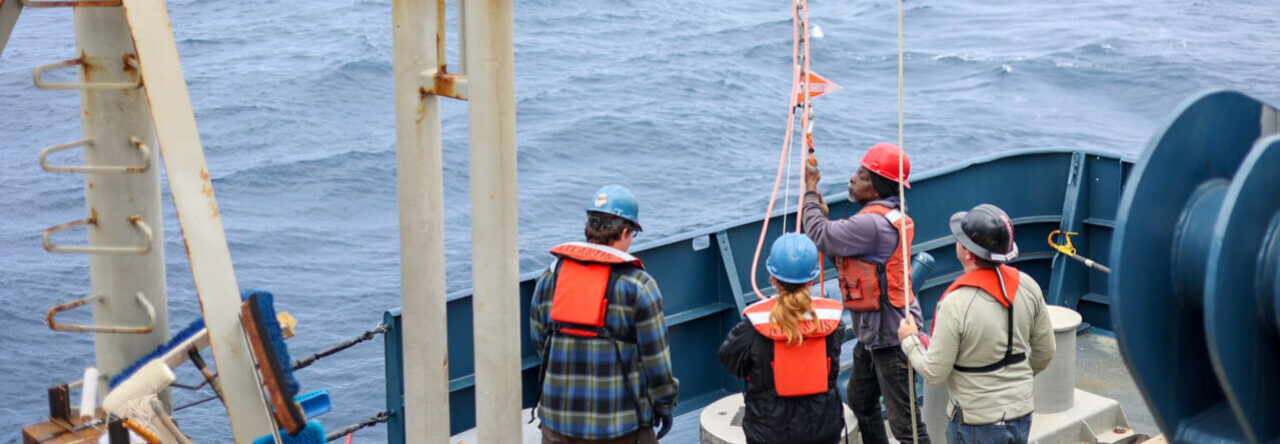
Today was the first day of sailing for the 03d cruise. Originally we were supposed to set sail on April 1st but multiple factors prevented this from happening. Due to the tremendous size of these moorings we have to carefully consider the sea state and equipment being used to deploy the gear. While we had relatively calm seas on the 1st we discovered that our Heavy Lift Winch (HLW – a specially designed winch built just to handle these buoys) was having multiple issues. The first is that its use appeared to be creating an unsafe energy surge in the ships generator. Luckily the ships engineers were able to fix the issue (though I’m unsure what they did). The second issue that we came across was a hysteresis problem. Once we had solved all of our HLW problems we were able to load the ship with our first buoy.
Overall the deployment of the buoy went all right but it could definitely be labeled as stressful. One wrong move and it would not just be an expensive instrument on the line but more importantly someone’s life. Due to this being my first major cruise I sat back for the deployment to watch and understand the overall operation. Due to the calm weather we were able to take the deployment nice and slow, so over the period of an hour we had finally deployed the whole setup without any issues. For the most part the only scary part of this deployment was getting the actually buoy over the side and trying to keep it under control. We had used all the available points for tag lines but it would have benefitted to have more to keep it in control when it got in the air and over the side as it had started to swing quite a bit before we could get it in the water. Figures 3, 4, and 5 show the buoy and its connected parts.
Once we had completed the Mooring deployment we moved on to retrieving a small “surface piercing profiler (SPP)”. During this operation I actually got to help as I ran the A-frame under the direction of our AB Doug. After we completed the retrieval we headed back to the dock for the night and are currently loading the next mooring as I type. Overall this cruise is off to a decent start.

*Image may not show on certain browsers. Compatible browsers appear to be Safari and Internet Explorer
Figure 3. Concept drawing for the Endurance shelf mooring consisting of the buoy (2), NSIF Instrument configuration assembly (1), HIB Module (6), and Multi functioning node/anchor (MFN- not numbered). All parts are connected by EM Chain (5, 12) and stretch hose (4). Diagram provided by OOI.

Figure 4. Surface Buoy Assembly

Figure 5. Full mooring setup being tested, attached buoy is for the inshore sites.

Figure 6. Deployment of the 80 m Shelf buoy.